Huntingdon County Information Page

Borough · Huntingdon County

Marklesburg

2 stories on file, each with its sources. 1.0 square miles of land in the ridge and valley country of central Pennsylvania.

200
Population
2020 Census, P.L. 94-171
1.04 sq mi
Land area
2020 Census gazetteer
0.01 sq mi
Water
2020 Census gazetteer
837 ft
Elevation
Community reference point, checked against USGS
Borough
Type
GEOID 4206147544

The founding record

MARKLESBURG, a quiet and unpretending little village, is situated in the southwestern part of the township, near the head of James Creek. It is distant half a mile from the Huntingdon and Broad Top Railroad, and twelve miles southwest of Huntingdon, on the road leading from Huntingdon to Bedford. . David Brumbaugh and Mgtthew Garner were the owners of the land on which the village is located. It was a part of the tract which was for many years in dispute between the Bank of: North America and the heirs of Dr. Allison. The former of the two proprietors mentioned put an end to the conflict in titles by purchasing both claims. The town was laid out in the summer of 1844 by Jacob Cresswell, surveyor, and was named in honor of Gen. Joseph Markle, the Whig candidate for Governor of Pennsylvania. The first dwelling-house in the town was erected by Jacob Skyles in 1844. Jacob Hess, Sr., is. the present owner of the house. The second and third dwellings were also erected in 1844 by Frederick and Adam Garner. In the following year houses were erected by Anthony Beaver, Adam Zeigler, and others. : Marklesburg has now forty-eight dwellings, two churches, , Evangelica] Lutheran and Methodist Episcopal,, one school-house, three stores, a carriage-factory, two blacksmith-shops, one harnessshop, two shoe-shops, three cabinet- and joiner-shops, and one cooper-shop. J. Simpson Africa, History of Huntingdon and Blair Counties, Pennsylvania (Philadelphia: Louis H. Everts, 1883) · character 2,179,840 of the scanned text
Marklesburg, a quiet and unpretending little village, is situated in the southwest part of the township, near the head of James Creek. It is distant half a milefrom the Huntingdon and Broad Top railroad, at Grantville, and twelve miles southwest of Huntingdon, on the public road leading from Huntingdon to Bedford. David Brumbaugh, sr., and Matthew Garner, dec'd, were the owners of the land on which the village is located. It was a part of the tract which was for many years in dispute between the bank of North America and the heirs of Doctor Allison. The former of the two proprietors mentioned, put an end to the conflict in titles by purchasing both claims. .The village was laid out in the summer of 1844, by Jacob Cresswell, Esq., surveyor, and was named in honor of Gen. Joseph Markle, the Whig candidate for Governor. The first dwelling house was erected by Jacob Skyles, in 326 HISTORY OF HUNTINGDON COUNTY. 1844. The house was for a long time owned and occupied by Abraham Megahan, Esq.; Jacob Hess, sr., is the present owner. The second and third dwellings were also erected in 1844, by Frederick and Adam Garner. In the following year houses were erected by Anthony Beard, Adam Seigler and others.Milton Scott Lytle, History of Huntingdon County (Lancaster: William H. Roy, 1876) · character 629,465

Quoted from a work published before 1929 and therefore in the public domain in the United States. Spelling and punctuation are as printed, including nineteenth century spellings of place names. Scanned text carries optical character recognition errors; the character offset is given so the passage can be found and checked in the original.

2 stories

Stories from Marklesburg

Did you know? The flood of 1936 crested over Huntingdon County in the dark, in the small hours of March 18. And on two of our creeks it still did not beat 1889.

The United States Geological Survey had gages running here that week and published every reading two years later. Second feet below is the old way of saying cubic feet of water going past a point every second.

Great Trough Creek near Marklesburg peaked around midnight going into the eighteenth, at about 9,580 second feet. The biggest thing that gage had recorded in the six years before was 2,180.

Shaver Creek near Petersburg reached a stage of 9.32 feet at 3:15 that morning, measured afterward off the flood marks.

Aughwick Creek near Orbisonia crested at 3:30 a.m. at 16,400 second feet, 19.16 feet on the gage.

Standing Stone Creek, three and a half miles up from Huntingdon, topped out around 9:30 a.m. at about 5,070 second feet.

Now the part nobody expects. On Aughwick Creek the Survey records a bigger flood than 1936, and it is June 1889: about 18,400 second feet, 20.5 feet, read off flood marks. On Standing Stone Creek the maximum known stage in the whole record is also 1889, 9.38 feet on the first of June.

Two of our creeks had already seen worse, forty seven years earlier.

Tell us what they said.

What the fact check changed. DUPLICATE OF 48e017a36dde5c6c, found by error-marker sweep rather than by clustering (text overlap 0.59 with the corrected original). Same post, same defect, same correction, no new research. ERROR MARKERS STILL PRESENT: "portstown", "sweeping away bridges" This copy is NOT YET PUBLISHED, so the correction is preventive. ---- ORIGINAL VERDICT NOTES FOLLOW: TWO CLAIMS CUT, and the post was rebuilt on federal measure…

Open this story on its own page →

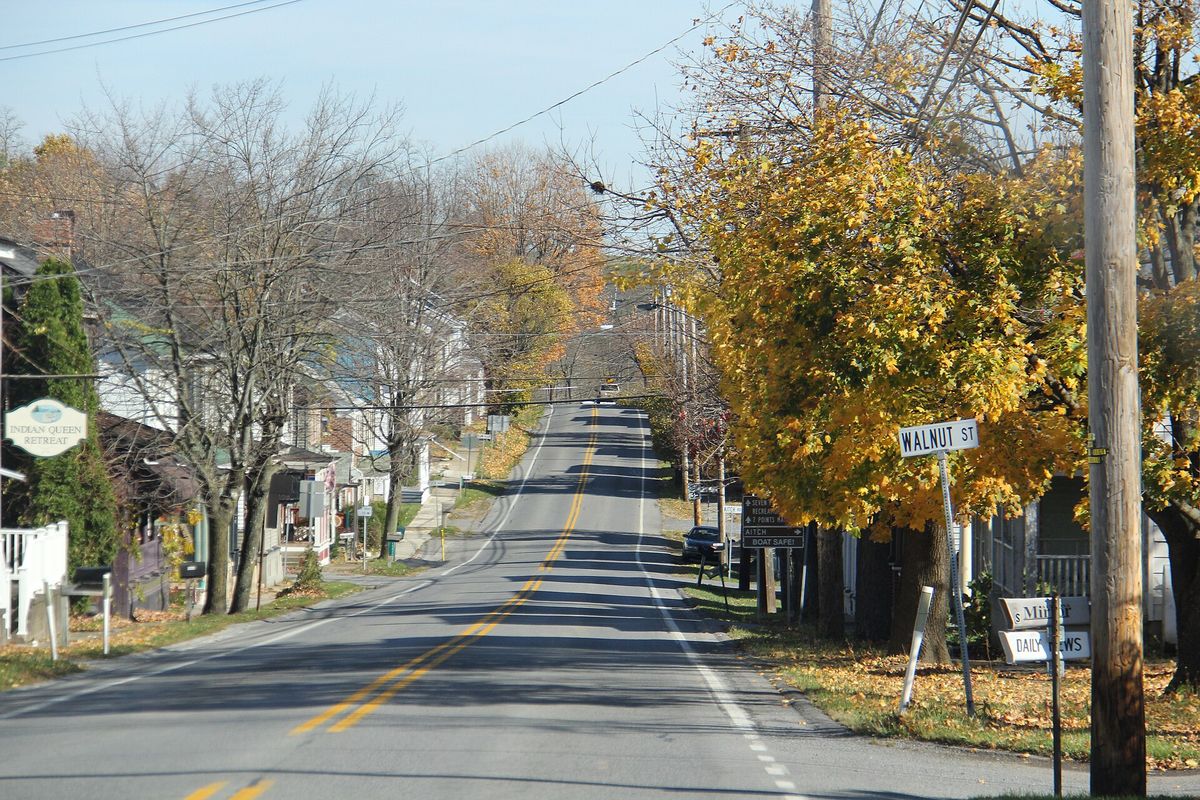
The Raystown Lake country in late fall, photographed 8 November 2014 in Marklesburg borough
The Raystown Lake country in late fall, photographed 8 November 2014 in Marklesburg boroughPhotograph by Ron Shawley, 8 November 2014, from the Panoramio archive. Licensed CC BY 3.0; reused with credit. Raystown lake Region late Fall - panoramio (35).jpg

Ron Shawley photographed the Raystown Lake country in the first week of November 2014 and gave the whole series one caption: Raystown lake Region late Fall. It names no township, and it did not need to - the file carries the coordinates the camera recorded, and the Census places that point inside Marklesburg borough.

What the fact check changed. The caption names no place, so the subject was established from the photograph's own coordinates against the Census geocoder, which returns Huntingdon County, Marklesburg borough.

Open this story on its own page →

Where it sits

Alexandria borough: 3 storiesBirmingham borough: 2 storiesBroad Top City borough: 2 storiesCassville borough: 2 storiesCoalmont borough: 2 storiesDudley borough: 2 storiesHuntingdon borough: 22 storiesMapleton borough: 3 storiesMarklesburg borough: 2 storiesMill Creek borough: 2 storiesMount Union borough: 131 storiesOrbisonia borough: 6 storiesPetersburg borough: 2 storiesRockhill borough: 2 storiesSaltillo borough: 2 storiesShade Gap borough: 2 storiesShirleysburg borough: 2 storiesThree Springs borough: 4 storiesBarree township: 3 storiesBrady township: 2 storiesCarbon township: 2 storiesCass township: 2 storiesClay township: 2 storiesCromwell township: 3 storiesDublin township: 4 storiesFranklin township: 2 storiesHenderson township: 4 storiesHopewell township: 2 storiesJackson township: 2 storiesJuniata township: 4 storiesLincoln township: 3 storiesLogan township: 2 storiesMiller township: 4 storiesMorris township: 2 storiesOneida township: 3 storiesPenn township: 2 storiesPorter township: 3 storiesShirley township: 5 storiesSmithfield township: 2 storiesSpringfield township: 3 storiesSpruce Creek township: 3 storiesTell township: 3 storiesTodd township: 2 storiesUnion township: 4 storiesWalker township: 4 storiesWarriors Mark township: 3 storiesWest township: 2 storiesWood township: 2 storiesHuntingdonMount UnionOrbisoniaThree SpringsPetersburgMapletonAlexandriaRockhillBroad Top CitySaltillo
10 or more4 to 91 to 3borough outline