Huntingdon County Information Page

Township · Huntingdon County

Warriors Mark

3 stories on file, each with its sources. 29.4 square miles of land in the ridge and valley country of central Pennsylvania.

1,871
Population
2020 Census, P.L. 94-171
29.36 sq mi
Land area
2020 Census gazetteer
Township
Type
GEOID 4206181104

The founding record

Warriors Mark, the most northwestern township of the county, was erected from Franklin in January, 1798. Originally it included a portion of Snyder and Tyrone townships, now in Blair county, and a part of the present county of Center. It is bounded on the northwest and southwest by Blair county ; on the northeast by Center county ; and on the southeast by Franklin township. It derived its name from a settlement in the central part, established at an earlier date. There is a tradition, not very well defined, that the Indians had marks of some kind upon the trees near the settlement, indicating a meeting place or place of holding councils. Michael Maguire, who settled there in 1773, said some years later that the marks were stones placed in the forks of four oak trees and that these stones were almost covered by the growth of the trees. John Baynton, Samuel Wharton and probably some others, who came in 1766, were probably the first settlers. Nathan and Thomas Ricketts came in 1777, and when th*" township was organized in 1798 there were over one hundred land owners. It was of logs, but later was replaced by a stone building, of which James Thompson, an old settler, said "That school house cost a drink of whislcy for every stone in it." John W. Jordan, ed., History of the Juniata Valley and Its People (New York: Lewis Historical Publishing, 1913) · character 206,290 of the scanned text

Quoted from a work published before 1929 and therefore in the public domain in the United States. Spelling and punctuation are as printed, including nineteenth century spellings of place names. Scanned text carries optical character recognition errors; the character offset is given so the passage can be found and checked in the original.

3 stories

Stories from Warriors Mark

Did you know? Nobody is certain how Warriors Mark got its name, and the county history says so in plain words.

The 1883 county history opens the question with this: "The origin of the name of the township is not clearly settled." Then it gives two different accounts, neither of them firsthand.

Michael Maguire came to the county with his parents in 1773. In a statement he made in 1845, he said there were marks on trees near where Warrior's Mark Town now stands, made by Indian warriors.

The second account is stranger. Henry Krider, who owned and lived on the farm northwest of the village, walked the historian out into the woods south of the turnpike and showed him the remains of four forked oak trees standing at the corners of a square. In the fork of each one sat a stone, almost completely swallowed by layers of new wood grown over it. Krider called those the Warrior's Marks, and said he had heard a tradition that the spot was a favored camping place.

The township itself is on firmer ground. The court created it at the January 1798 term, after people in Franklin township petitioned that their township "in its present situation is burdensome and inconvenient by reason of its extent and number of inhabitants." The same court appointed John Addleman constable and Nicholas Hewitt overseer of the poor.

Four oak trees with stones grown into the forks.

What the fact check changed. FOUR CLAIMS CUT. This post took a source that explicitly says it does not know, and made it certain. 1. THE HEDGE WAS UPGRADED. Africa 1883 says flatly "The origin of the name of the township is not clearly settled." The queued post says "According to tradition recorded in the county histories, Iroquois warriors traveling the Great Indian Warpath ceremonially marked trees in the forest near the present village." That…

Read the full story, with 3 passages quoted from the county histories →
Did you know? A Huntingdon County town was once sold off by lottery, and the lottery is a big part of why it never became the city it was drawn up to be.

On December 13, 1797, John Cadwallader laid out Birmingham on the north bank of the Little Juniata, about three miles below where Tyrone sits now. The county history says it was laid out "for a manufacturing town, at the head of navigation." Three hundred acres. Streets from sixty six to two hundred feet wide. Two lots set aside for a school house and a library hall, and four lots promised to any established religious society that wanted to build a church and a burial ground.

Then came the part that sank it. The lots were sold by ticket. Ten dollars for a town lot, five dollars down. Which lot you actually got was drawn by ballot, overseen by five freeholders who had to swear or affirm to act impartially before they could start. People in eastern cities bought in without ever standing on the ground.

The history is blunt about what the plan hid. It was "made to look very attractive to a people who knew nothing of the steep hills and ravines included within the limits of the plat." When buyers came to see what they had drawn, a good many found their lot "perched upon a steep hillside or in the bottom of a deep hollow," and they walked away from money they had already paid.

The great city never came. The village is still there.

What the fact check changed. ONE CLAIM CUT, and it was the whole hinge of the original post: "Then the Pennsylvania Railroad built its great hubs at Tyrone and Altoona instead." Africa 1883 does not say that. What it says is general and hedged: "the proximity to other points more advantageously located has since the completion of the railway built them up while Birmingham has steadily declined." It names no hub, no Altoona, and it puts the railw…

Read the full story, with 3 passages quoted from the county histories →

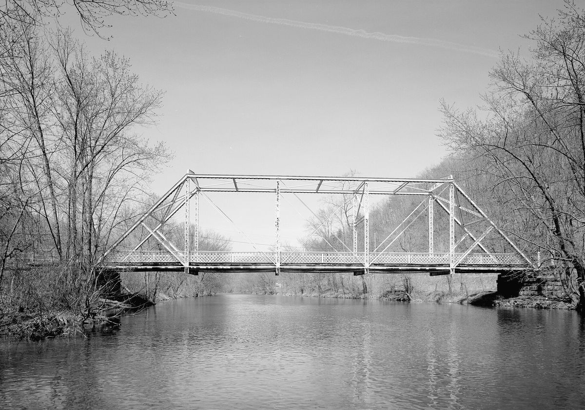
Southern (downstream) side of the Birmingham Bridge, spanning the Juniata River north of Birmingham
Southern (downstream) side of the Birmingham Bridge, spanning the Juniata River north of BirminghamJet Lowe, Historic American Engineering Record, Library of Congress. Public domain, a United States Government work. HAER PA,7-TYRO.V

The Birmingham Bridge carries Pennsylvania Route 350 over the Juniata north of Birmingham, and it does not belong to one county. Its far end is in Tyrone Township, Blair County; its near end is in Warriors Mark Township, Huntingdon County. The Historic American Engineering Record photographed it in March 1988 from the downstream side. The photographer was Jet Lowe, whose plates of the Harbison-Walker works appear elsewhere on this site.

Open this story on its own page →

Where it sits

Alexandria borough: 3 storiesBirmingham borough: 2 storiesBroad Top City borough: 2 storiesCassville borough: 2 storiesCoalmont borough: 2 storiesDudley borough: 2 storiesHuntingdon borough: 22 storiesMapleton borough: 3 storiesMarklesburg borough: 2 storiesMill Creek borough: 2 storiesMount Union borough: 131 storiesOrbisonia borough: 6 storiesPetersburg borough: 2 storiesRockhill borough: 2 storiesSaltillo borough: 2 storiesShade Gap borough: 2 storiesShirleysburg borough: 2 storiesThree Springs borough: 4 storiesBarree township: 3 storiesBrady township: 2 storiesCarbon township: 2 storiesCass township: 2 storiesClay township: 2 storiesCromwell township: 3 storiesDublin township: 4 storiesFranklin township: 2 storiesHenderson township: 4 storiesHopewell township: 2 storiesJackson township: 2 storiesJuniata township: 4 storiesLincoln township: 3 storiesLogan township: 2 storiesMiller township: 4 storiesMorris township: 2 storiesOneida township: 3 storiesPenn township: 2 storiesPorter township: 3 storiesShirley township: 5 storiesSmithfield township: 2 storiesSpringfield township: 3 storiesSpruce Creek township: 3 storiesTell township: 3 storiesTodd township: 2 storiesUnion township: 4 storiesWalker township: 4 storiesWarriors Mark township: 3 storiesWest township: 2 storiesWood township: 2 storiesHuntingdonMount UnionOrbisoniaThree SpringsPetersburgMapletonAlexandriaRockhillBroad Top CitySaltillo
10 or more4 to 91 to 3borough outline