Mount Union borough
The tie yard, 1950s
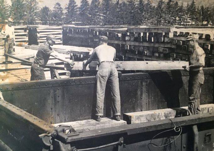
The Pennsylvania Railroad tie yard in the 1950s. Mount Union wasn't just brick, millions of wooden crossties passed through the PRR's treating operation here on their way to the main line.
From the record
Passages about this subject, quoted from county histories now in the public domain. Each one names the book and the position in the text so it can be checked. Spelling is as printed.
The East Broad Top railroad connects with the Pennsylvania railroad at Mount Union and runs south through Shirleysburg, giving the township and outlying region ample transportation facilities. Smithiield is one of the newer townships of the county, having been organized in March, 1886, from Porter, Walker, and Juniata. It lies directly across the Juniata river from Huntingdon borough, the village of Smithfield forming practically a suburb of the county seat. The Huntingdon & Broad Top railroad runs southwest through the township. Springfield township, located in the southern part of the county, was organized in December, 1790, from the townships of Dublin and Shirley. Its original area has been much reduced by the erection of Cromwell in 1836 and Clay in 1845. It is bounded on the north by Cromwell ; on the east by Dublin ; on the south by Fulton county, and on the west by the township of Clay. John Bailey, a Revolutionary soldier, settled on the banks of the Aughwick creek soon after that war. He was soon joined by William Jones, John Robertson and William Ward. Then came a tide of immigration from Maryland, the Browns, Maddens, Ramseys, Lanes, Cutshalls, Wibles, and several other families locating in what is now Springfield township.John W. Jordan, ed., History of the Juniata Valley and Its People (New York: Lewis Historical Publishing, 1913) · character 200,907 of the scanned text
Miles & Dorris were the resident attorneys of the Pennsylvania Railroad Company during the time of its construction, and until the dissolution of the firm, and Mr. Dorris has been continued in that capacity down to the present time. * During the war of the Rebellion, in 1862, Mr. of Pennsylvania Militia, and served during the threatened invasion which was repelled at Antietam. Joun Scorr was born at Alexandria, on the 14th of July, 1824, and is of Scotch-Irish descent. His father, also named John Scott, was a major of volunteers in the war of 1812, and was elected to Congress in 1828, in the district composed of the counties of Huntingdon, Mifflin, Centre, and Clearfield, and represented said district in the Tw nty-First Congress. His son, the subject of this brief sketch, received such an education as the schools of his native village afforded, and afterwards was instructed by private teachers in Latin and Greek. In 1842 he entered as a student the law office of Alexander Thompson, in Chambersburg, and at the end of the usual course of study was admitted to the bar.J. Simpson Africa, History of Huntingdon and Blair Counties, Pennsylvania (Philadelphia: Louis H. Everts, 1883) · character 619,346 of the scanned text
Gorsuch and Union Church, near the center of the township, and Ardenheim, a small station on the Pennsylvania railroad, two miles east of Huntingdon, are the only villages of consequence. Hopewell township was erected in July, 1773, when the Bedford county court ordered that "that part of Barre township including all the waters that empty into the Raystown Branch of Juniata below the mouth of Yellow Creek and up said creek to Tussey's Mountain is hereby erected into a township by the name of Hopewell township." It was therefore one of the six original townships when the county was erected in 1787. Union township was taken from it in 1791 ; Penn in 1846, and Lincoln in 1866. These curtailments have left it one of the smallest townships in the county. It is located in the southwest corner and is bounded on the north by Lincoln township; southeast by Tod and Carbon, from which it is separated by Terrace mountain ; southwest by Bedford county, and northwest by the county of Blair. The Huntingdon & Broad Top railroad traverses it from northeast to southwest and the Raystown branch of the Juniata follows the same general direction.John W. Jordan, ed., History of the Juniata Valley and Its People (New York: Lewis Historical Publishing, 1913) · character 187,991 of the scanned text
Sources
No source list was recorded with this item when it was written. It is shown here as written and has not been re-verified. Treat it as unverified until it has been.
Checked 2026-07-21 · Historic Mount Union collection
More from Mount Union borough
This stone house stands on West Water Street near Division. The federal survey records it as the John Sharrar House and…
Mount Union boroughThe Brick Office that Became the Red CrossLook at the sign in the yard. This little brick building on Market Street was the General Refractories Company office.…
Mount Union boroughAetna Explosion 1916Did you know? The building that killed six men at Mount Union had been catching fire all summer, and the paper reported…